Skip to content
survey logo
SurVey
Geodesy And Topographic Surveying
Shuffle
  • Home
  • Fundamentals and Techniques of Geodesy
  • Applications in various industries
  • About
  • Contact
  • Privacy Policy

Category: Blog

Blog Fundamentals and Techniques of Geodesy

3 Reasons Why An Alta Survey Is Needed

  • Post Author By Russell Olson
  • Post Date 24/10/2023
  • Post Comment 0 comments
Why An Alta Survey Is Needed
Estimated read time 2 min read

An ALTA is a survey that is used by a set of national standards rules. As the American Land Title Association and the National Society [Read More…]

Leave a Comment on 3 Reasons Why An Alta Survey Is Needed
Blog Fundamentals and Techniques of Geodesy

What is a Topographical Land Survey?

  • Post Author By Russell Olson
  • Post Date 19/10/2023
  • Post Comment 0 comments
Estimated read time 2 min read

A topographical survey is an important tool used by a variety of professionals, from architects and builders to engineers and public authorities. Now you may [Read More…]

Leave a Comment on What is a Topographical Land Survey?
Applications in various industries Blog Fundamentals and Techniques of Geodesy

Why Land Surveying Is Important

  • Post Author By Russell Olson
  • Post Date 19/10/2023
  • Post Comment 0 comments
Land Surveying
Estimated read time 3 min read

Land surveying involves measuring and mapping the world around us using mathematics, advanced software and equipment. Surveyors calculate just about anything in the ground, in [Read More…]

Leave a Comment on Why Land Surveying Is Important
Blog

How Is a Topographical Survey Important?

  • Post Author By Russell Olson
  • Post Date 16/10/2023
  • Post Comment 0 comments
Topographical Survey
Estimated read time 3 min read

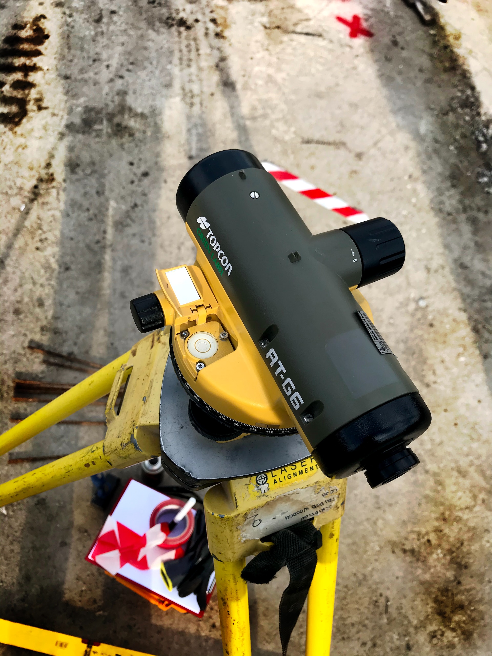
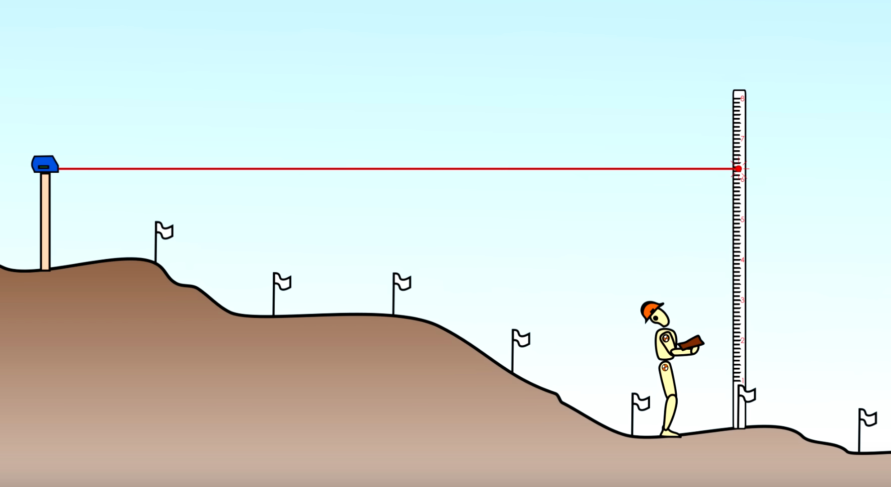
A topographical survey is different from other surveys by studying and measuring the surface of the land. Topographical survey measurements are carried out using both [Read More…]

Leave a Comment on How Is a Topographical Survey Important?
Blog Fundamentals and Techniques of Geodesy

Importance of GPS for Land and Construction Surveying

  • Post Author By Russell Olson
  • Post Date 16/10/2023
  • Post Comment 0 comments
tacheometer
Estimated read time 2 min read

According to research, the US military developed the Global Positioning Systems (GPS) in 1973 with the help of the first satellites that were launched in [Read More…]

Leave a Comment on Importance of GPS for Land and Construction Surveying
Blog

Sidewalk or Curb – What Decides Your Property?

  • Post Author By Russell Olson
  • Post Date 16/10/2023
  • Post Comment 0 comments
where does my property line start from the street
Estimated read time 5 min read

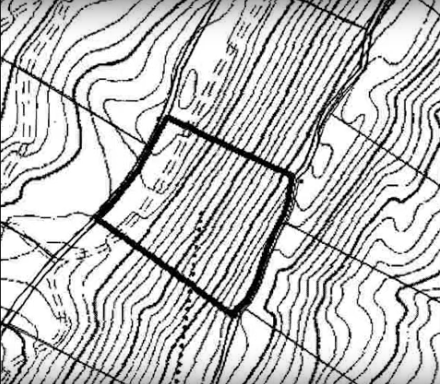
You’re not alone if you’ve ever questioned where your property boundary intersects with the street. There are almost as many different definitions for property lines [Read More…]

Leave a Comment on Sidewalk or Curb – What Decides Your Property?
Blog Fundamentals and Techniques of Geodesy Land and Topographical Surveying

The Importance of Land Survey for Construction Staking

  • Post Author By Russell Olson
  • Post Date 07/10/2023
  • Post Comment 0 comments
land survey
Estimated read time 3 min read

Land surveyors are required to offer precise information on the land when civil engineers initially prepare to develop a property. As a result, civil engineers [Read More…]

Leave a Comment on The Importance of Land Survey for Construction Staking
Blog Land and Topographical Surveying

Learn More about Land Survey

  • Post Author By Russell Olson
  • Post Date 05/10/2023
  • Post Comment 0 comments
terrain elevation
Estimated read time 2 min read

When you intend to buy a property or develop a piece of land, you may come across many arguments. To make an end to this [Read More…]

Leave a Comment on Learn More about Land Survey
Blog

What Are the 3 Qualities Every Land Surveyor Should Have?

  • Post Author By Russell Olson
  • Post Date 17/08/2023
  • Post Comment 0 comments
Estimated read time 3 min read

Property developers know that they wouldn’t get very far without the service of a good land surveyor. Before you hire anyone for the job, keep [Read More…]

Leave a Comment on What Are the 3 Qualities Every Land Surveyor Should Have?
Blog

Vegetation and Surveying – What Is the Challenge?

  • Post Author By Russell Olson
  • Post Date 31/05/2023
  • Post Comment 0 comments
Vegetation and Surveying
Estimated read time 3 min read

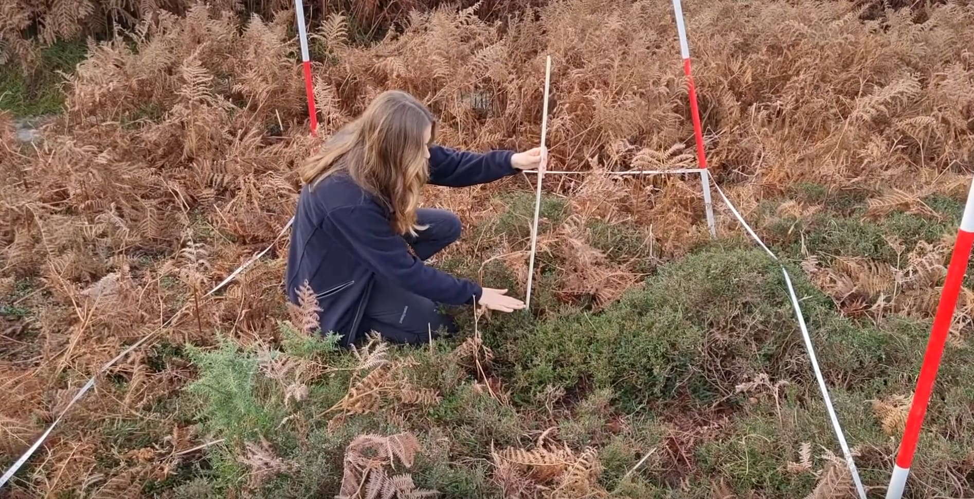
The necessity of surveying areas covered by thick vegetation is one of the obstacles faced while employing traditional land surveying methods. Some surveying projects necessitate [Read More…]

Leave a Comment on Vegetation and Surveying – What Is the Challenge?

Posts navigation

← Older Posts
→ Newer Posts

Recent Posts

  • Understanding Agricultural Zoning: What It Allows and Its Impact
  • Finding the Perfect Fence Contractor: Your Guide to a Great Barrier!
  • Diving Deep into the Versatile Applications of Topographical Surveys
  • How Does a Surveyor Determine Property Lines: The World of Land Surveying
  • Digging Deep into Construction Staking: The Essential Guide
  • What Types of Backlinks Should Companies Build?
  • A Comprehensive Handbook For Registered Surveyors

Categories

  • Applications in various industries
  • Blog
  • Fundamentals and Techniques of Geodesy
  • Land and Topographical Surveying

Archives

  • June 2024
  • January 2024
  • October 2023
  • August 2023
  • June 2023
  • May 2023
  • April 2023
  • March 2023
  • February 2023
  • December 2022
  • September 2022
  • May 2022
  • March 2022
  • November 2021
  • July 2020
  • October 2018
  • April 2018
  • August 2017

Categories

  • Applications in various industries
  • Blog
  • Fundamentals and Techniques of Geodesy
  • Land and Topographical Surveying

You May Also Like:

Understanding Agricultural Zoning: What It Allows and Its Impact
Blog

Understanding Agricultural Zoning: What It Allows and Its Impact

Posted on 03/06/2024 by Russell Olson
Finding the Perfect Fence Contractor: Your Guide to a Great Barrier!
Applications in various industries

Finding the Perfect Fence Contractor: Your Guide to a Great Barrier!

Posted on 30/01/202406/02/2024 by Russell Olson
Diving Deep into the Versatile Applications of Topographical Surveys
Applications in various industries

Diving Deep into the Versatile Applications of Topographical Surveys

Posted on 30/01/202406/02/2024 by Russell Olson
How Does a Surveyor Determine Property Lines: The World of Land Surveying
Fundamentals and Techniques of Geodesy

How Does a Surveyor Determine Property Lines: The World of Land Surveying

Posted on 29/01/202403/06/2024 by Russell Olson
Digging Deep into Construction Staking: The Essential Guide
Land and Topographical Surveying

Digging Deep into Construction Staking: The Essential Guide

Posted on 27/01/202401/02/2024 by Russell Olson
What Types of Backlinks Should Companies Build?
Blog

What Types of Backlinks Should Companies Build?

Posted on 25/01/202406/02/2024 by Russell Olson

What is geodesy?

What is geodesy and surveying in construction
The sphere that geodesy studies includes the relationship to determine the coordinates and heights of points on the surface of the Earth, as well as objects in space. These objects are land and real estate: buildings, structures, linear objects inseparably connected with the land.

What Types of Backlinks Should Companies Build?

What is the difference between a topographic survey and a surveying survey?

A topographic survey does not differ from a geodetic one; the difference between geodesy and topography is only in the specifics of the subject of the survey. The geodetic survey as an object can have a plot of land, the facade of a house or the installation structures during the construction phase.

What is a topographic survey done for?

With the help of a topographical plan you can get a clear picture of the terrain with its differences and heights, with the presence of underground utilities, with the presence of all the capital and non-capital objects erected on it. With a topographic plan in hand, you can carry out construction and design work.

How is a geodetic survey conducted?

Geodetic survey is a large-scale complex measurement of terrain, distances and angles and their subsequent transfer to the map. It is carried out taking into account the referencing to the map of the area, the directions of the world and special marks. As such reference points can be any constructions made

Copyright © 2025 All rights reserved.

Scroll to top
  • Home
  • Fundamentals and Techniques of Geodesy
  • Applications in various industries
  • About
  • Contact
  • Privacy Policy