
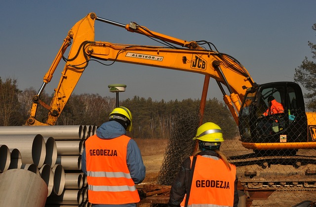
In this procedure, the land surveyor makes maps of various features of a property and the legal boundaries. The specialists can measure the necessary structures and locate the features of the property. The specialists use various types of tools including an altimeter. It is used to measure the elevation of the property. GPS is another beneficial tool while they want to complete the survey. One of the most important tools is theodolite.
The expert uses the tool to measure the vertical and horizontal angles between points. The land surveyor should have a Surveyor’s Certificate and he or she has to make a personal and professional affidavit.
The Process
-
Beginning Phase
However, the entire process is not about only point out a plot. If there is any type of evidence, then it also helps the land surveyors to evaluate the true boundaries of the property. First, the experts have to read all the pertinent documents such as maps, wills, deeds before starting the survey. You can find it in the county records office. Only a land surveyor can understand the complex documentation and interpret the accurate property lines.
After they read all the documentation, now, they have to check if there is any physical evidence about the boundaries. The following evidence is the existing fence, marker. If the property is too old, then most of the time it is very difficult to find the original physical evidence as it is not permanent.
-
Middle Phase
However, after evaluating all the research and the physical evidence, now the land surveyor has to establish the true boundary of the property. If there is not change happen till now and the expert finds all the evidence, then, in that case, he or she can mark the property lines with new markers.
-
Last Phase
After marking the property line, now, they have to prepare the property description. They should include various elements such as delineation of the topography of the property, corner monuments, a representation of recent works which should be man-made within the survey line, the direction and length of each line and the relationship to adjoining official surveys. The land surveyor should mention a few information like the date of the survey, the name of the surveyor, unique data that is related to the property and the scale of the plat.
Contact Us
If you want to survey your property accurately, then you should contact the experts of Red Hawk Surveying in OKC.


+ There are no comments
Add yours