

In the world of real estate and property management, clarity and precision are paramount. Whether you’re a property owner, a prospective buyer, a developer, or simply a concerned neighbor, understanding property boundaries is fundamental to making informed decisions and avoiding legal disputes. This is where a boundary survey comes into play, offering a definitive answer to the age-old question: “Where does my property end, and my neighbor’s begin?”
Understanding the importance of backlinks in digital marketing is crucial for companies striving to boost their online presence. Dive into the intricacies of effective link building strategies with our insightful article: What Types of Backlinks Should Companies Build?
What is a Boundary Survey?
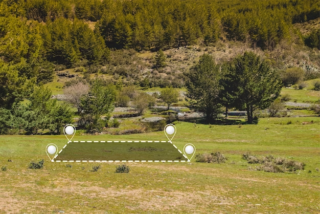
Professional surveyors perform a boundary survey, which is more commonly known as a property or land boundary survey. This process aims to establish the precise boundaries of an estate and is crucial in:
| Purpose | Description |
| Identifying Property Lines | Clarifying the boundaries of a property is crucial, and that’s where a boundary survey comes in handy. It furnishes property owners with an accurate comprehension of their land’s limits, which proves particularly helpful during buying or selling processes and when utilizing it for diverse objectives since it eliminates any vagueness or doubt concerning its borders. |
| Resolving Disputes | Instances of disagreements with neighbors regarding property boundaries can lead to substantial conflict and legal complications. To address such disputes, a boundary survey can offer an exact representation of the land’s demarcations. With a well-defined professional delineation in place, it becomes more feasible to reach amicable compromises or seek legal respite if required for resolution purposes. |
| Regulatory Compliance | To conform with zoning laws and building codes imposed by regulatory authorities or local governments for land usage and development, a boundary survey proves critical. Such surveys define property boundaries accurately, thus preventing legal issues or violations that may arise from planning construction projects or other property improvements. |
| Property Development | To plan and carry out development projects on a parcel of land, developers and property owners depend heavily on boundary surveys. Precise knowledge regarding boundaries is crucial in determining the suitable areas for constructing structures, subdividing plots and positioning infrastructure such as roads, utilities & drainage systems. This ensures that all developments take place within permissible legal confines while also guaranteeing a successful outcome to any project undertaken. |
Key Components of a Boundary Survey
Delving into the detailed components of a boundary survey, this critical procedure is utilized to accurately identify property lines and notable landmarks on a particular plot of land. The process incorporates various tasks such as fieldwork, research, mapping and reporting that aid in obtaining precise results. Through analyzing each phase thoroughly we aim to provide valuable insights regarding its significance within the overall boundary surveying practice.
Field Survey
Accurately identifying and marking the boundaries of a property is dependent upon conducting a foundational field survey that involves physical measurement and assessment. This critical step also takes into account any existing features, making it crucial to ensure precision in boundary identification. The following are key elements involved in performing a thorough field survey:
- Property Boundary Measurements: Professional surveyors utilise specialized tools including total stations, GPS receivers and theodolites to precisely measure and record distances, angles as well as points of elevation along property boundaries.
- Property Corner Identification: Identification of Property Corners involves the task carried out by surveyors to locate and authenticate property boundaries using markers such as boundary monuments or markers. These points provide a reliable reference for the entire land survey process.
- Natural and Man-Made Features: Surveyors document a range of natural and human-made features, which may include trees, buildings, fences, roads, waterways and infrastructure that fall within or close to the boundaries of the property.
- Topographic Data: To guarantee precise mapping and evaluation, data related to topography such as alterations in altitude, contours, and additional terrain attributes is gathered.
Research
The comprehensive study of historical documents and past surveys linked to the property comprises the research phase. It plays a critical role in comprehending the property’s background and authenticating its existing boundaries. The core components of this phase encompass:
- Deed Analysis: Surveyors analyze property deeds and legal documents to acquire knowledge about previous boundary descriptions and rights of passage.
- Historical Maps: To trace the development of a property over time, one can analyze historical maps, aerial imagery and property records.
- Public Records: Accessing public records and databases, surveyors gather information on easements, zoning regulations, and land-use restrictions that could potentially impact the property.
Mapping
The creation of precise maps that display important information about property boundaries, features and other relevant details is known as mapping. These visual aids accurately depict the survey’s discoveries, and are a crucial element in the process. Important components include:
- Boundary Plat: A detailed illustration that depicts property boundaries, dimensions, corner locations along with discrepancies and encroachments found during the survey is called a Boundary Plat.
- Site Plan: A site plan, inclusive of topographical nuances alongside current structures and notable natural characteristics can be created by surveyors.
- GIS Integration: The utilization of Geographic Information System (GIS) technology is common practice to improve precision in mapping and preserve spatial data for upcoming usage, thus facilitating GIS integration.
Reporting
Compiling all collected data and findings into a comprehensive report is the ultimate stage of boundary surveying. This crucial step ensures that property owners, land developers, and legal purposes have access to essential information about the inspection process. Key elements involved in reporting include:
- Boundary Description: A comprehensive depiction detailing the boundaries and corners of a property along with any legally significant annotations.
- Surveyor’s Seal: The survey report usually bears the certification of accuracy and professionalism through the inclusion of the seal and signature by the surveyor.
- Surveyor’s Recommendations: The suggestions or recommendations made by surveyors may pertain to boundary disputes, encroachments, and necessary actions that property owners can take to resolve any issues.
- Legal Compliance: Ensuring legal compliance regarding property surveys by ensuring that the boundary survey report adheres to all relevant local laws and regulations.
When Would You Need a Boundary Survey?

A boundary survey holds immense significance in different scenarios as it assists property owners and buyers to comprehend property boundaries, prevent legal conflicts, and guarantee adherence to land division or construction regulations. Presented below is a discussion on the situations that would warrant needing a boundary survey.
Purchasing Property
In the context of purchasing property, which is one of your most substantial investments, it’s crucial to have a comprehensive knowledge about what you’re obtaining. A boundary survey becomes inevitable in this scenario for the following reasons:
- Accurately define the boundaries of a property.
- Ensure that the legal description and survey of the land you plan to buy correspond with each other.
- Detect any infringements, servitudes or inconsistencies that may impact the value and utilization of the property.
Obtaining a boundary survey prior to purchase can avoid potential future disputes, financial losses or unforeseen property complications.
Building or Renovating
It is crucial to ensure that your building project remains within the property lines if you intend to construct a new structure or renovate an existing one. Thus, it becomes necessary to obtain a boundary survey for this purpose.
- Builders can work within the designated area by using on-site markings to indicate property boundaries.
- In order to prevent encroachment onto adjacent properties, which may result in legal disputes.
- In order to comply with local building codes, zoning and setback requirements must be met.
The implementation of a boundary survey guarantees compliance with regulations for your construction undertaking and mitigates the possibility of expensive conflicts.
Property Disputes
Boundary conflicts over property can occur due to several reasons, like disputes with neighbors or uncertain descriptions of the land. When such issues arise, a boundary survey may be utilized to:
- Furnish an impartial and lawfully acknowledged assessment of the demarcations of a property.
- To settle disagreements and determine ownership rights, present proof in a legal setting.
- Assist landowners in comprehending their obligations and entitlements related to their property.
The boundary survey is an essential legal document that helps in resolving disputes and promoting peace among neighbors.
Subdividing Land
Subdividing land involves dividing a larger property into smaller lots for development or sale. A boundary survey is indispensable in this situation to:
- Accurately delineate the new property lines for each subdivided lot.
- Ensure compliance with local zoning and subdivision regulations.
- Provide legal documentation for property buyers or developers.
Subdividing land without a proper boundary survey can lead to legal complications, delayed approvals, and potential financial setbacks.
The Process of Conducting a Boundary Survey
A boundary survey is a crucial step in defining property boundaries, resolving property disputes, and ensuring landowners’ rights and responsibilities. Here’s a step-by-step process of conducting a boundary survey:
Initial Consultation
The initial consultation is the first step in understanding the client’s needs and objectives. During this phase, the surveyor establishes clear communication with the client to gather essential information. This includes:
- Property owner’s goals and requirements.
- Property history, such as previous surveys, deeds, and land records.
- Any existing property disputes or concerns.
- Desired accuracy level and survey standards (e.g., ALTA/NSPS or state-specific standards).
This consultation helps the surveyor tailor the survey to meet the client’s specific needs and ensures a clear understanding of the project scope and objectives.
Research
The research phase is crucial for gathering historical data and previous surveys. The surveyor conducts a thorough investigation, which may involve:
- Retrieving deeds, plats, and other property records from county or municipal offices.
- Collecting information on any easements, encroachments, or legal descriptions associated with the property.
- Identifying neighboring properties and their ownership records.
- Reviewing any historical aerial imagery or topographic maps that may provide insights into property boundaries.
This extensive research helps the surveyor establish a foundation for the boundary survey, ensuring accuracy and compliance with legal requirements.
Field Work
Field work is where the physical measurement of the property takes place. This stage involves precise measurements and data collection to determine the boundaries accurately. The field work includes:
- Establishing survey control points using GPS or other accurate geodetic methods.
- Conducting traverses, which involve measuring distances and angles between control points and relevant property features.
- Identifying and measuring existing improvements, such as buildings, fences, and utility lines.
- Collecting additional data on topography and natural features, as needed.
- Resolving any discrepancies or ambiguities encountered in the field.
Field work is a meticulous process, and the surveyor must adhere to recognized surveying standards and use advanced equipment for precise measurements.
Analysis
Once the field data is collected, the surveyor enters the analysis phase. During this stage, the surveyor interprets the data and applies mathematical calculations to determine the property boundaries. Key aspects of the analysis phase include:
- Resolving any discrepancies or inconsistencies in the collected data.
- Calculating boundary lines based on legal descriptions, deeds, and relevant laws.
- Identifying encroachments or boundary disputes and suggesting potential solutions.
- Ensuring compliance with local, state, and federal regulations.
The analysis phase requires a deep understanding of land surveying principles, legal aspects, and a keen eye for detail.
Reporting
The final stage of a boundary survey is the reporting phase, where the surveyor compiles and delivers detailed reports and maps to the client. The report should include:
- A clear and concise description of the property boundaries and any identified encroachments or issues.
- A plat or map displaying the surveyed boundaries, control points, and relevant property features.
- Legal descriptions, references to deeds, and surveyor’s certification.
- Recommendations for resolving boundary disputes or discrepancies.
The surveyor should provide the client with a comprehensive and well-organized document that can be used for legal purposes, property transactions, or other land-related matters.
Why Boundary Surveys are Essential
Legal Clarity
Boundary surveys serve as a foundational legal document that establishes precise property boundaries. This legal clarity is indispensable for several reasons:
- Property Ownership: Boundary surveys definitively determine the boundaries of a property, ensuring that landowners know exactly what they own and what is adjacent to their property.
- Property Rights: They help protect property rights by confirming the extent of one’s land and identifying any encroachments or encumbrances.
- Legal Record: Boundary surveys serve as a permanent legal record, often filed with local authorities, which can be referenced in the event of disputes, property sales, or other legal proceedings.
- Adherence to Regulations: They ensure that property owners comply with local zoning and building regulations by establishing accurate property dimensions.
- Boundary Markers: Physical boundary markers placed during a boundary survey can serve as visual indicators of property lines, further reinforcing legal clarity.
Conflict Avoidance
Boundary disputes can be costly, time-consuming, and emotionally taxing. Boundary surveys play a crucial role in conflict avoidance:
- Neighborly Disputes: By clearly defining property lines, boundary surveys minimize the risk of disputes with neighbors over encroachments or land use disagreements.
- Legal Disputes: When disputes do arise, the survey serves as objective evidence in court, simplifying the resolution process and reducing litigation costs.
- Local Authorities: Local authorities may require boundary surveys to approve building permits or property subdivisions, ensuring that land use adheres to zoning regulations and avoiding potential conflicts.
- Peace of Mind: Property owners can have peace of mind knowing that their boundaries are legally established, reducing anxiety and uncertainty.
Facilitating Transactions
Boundary surveys are essential in various property-related transactions:
- Property Sales: They provide critical information to both buyers and sellers, ensuring that the property’s extent is accurately represented in the sale agreement.
- Property Purchases: Buyers can make informed decisions based on the survey’s findings, reducing the risk of purchasing land with boundary issues.
- Property Development: Developers rely on boundary surveys to plan and execute construction projects within property lines, avoiding legal complications and setbacks.
- Title Insurance: Many title insurance companies require boundary surveys to issue policies, assuring buyers that the property has clear and undisputed boundaries.
Conclusion
Understanding what a boundary survey is and its differences from a land survey is vital for anyone involved in property-related endeavors. While a boundary survey focuses specifically on determining property lines, a land survey provides a broader overview of the land’s topographical and structural features. Conducting a boundary survey is a critical step in ensuring legal clarity, preventing disputes, and facilitating smooth property transactions.
In the ever-evolving world of real estate and property management, staying informed and proactive about boundary surveys can save you from potential legal hassles and conflicts. Whether you are buying a new property, planning construction, or simply need to settle a boundary dispute, a thorough property boundary survey is your first step towards peace of mind and legal security.
FAQ
Q: How often should I get a boundary survey?
A: It’s advisable to get a boundary survey when purchasing a property, planning significant changes, or if there’s a potential dispute.
Q: How long does a boundary survey take?
A: The time varies depending on property size and complexity, typically ranging from a few days to several weeks.
Q: Can a boundary survey affect my property taxes?
A: Yes, if the survey leads to a change in the recorded size of your property.
Q: What should I do if the boundary survey reveals a dispute?
A: Engage in a dialogue with involved parties and consider legal advice if necessary.
Q: Is a boundary survey legally binding?
A: Yes, boundary surveys are conducted by licensed professionals and are legally recognized.


